


La bahía de Newark (en inglés: Newark Bay) es una parte de la gran bahía de Nueva York, cercana a la Bahía Upper New York. Es una bahía de marea situada en la confluencia de los ríos Passaic y Hackensack y limita con la costa noreste de Nueva Jersey. La bahía pertenece principalmente al estado de Nueva Jersey, con una pequeña parte incluida en el vecino estado de Nueva York. Está separada de la Bahía Upper New York por la península de Bergen Neck. Las dos bahías están conectadas por el Kill Van Kull, un estrecho situado al sureste, que las separa de Staten Island, isla que forma parte de la Ciudad de Nueva York.[1] [2]
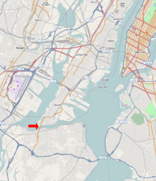
La bahía de Newark está conectada con la bahía de Raritan y la bahía de Lower New York, situada al sur de Staten Island, por Arthur Kill. Rodeando la bahía se encuentran las ciudades de Newark y Elizabeth, unidas a Ciudad de Jersey y Bayonne sobre Bergen Neck por el puente de la bahía de Newark o puente de Bayonne.
En esta bahía se ubica la Port Newark-Elizabeth Marine Terminal, las mayores instalaciones de contenedores del Puerto de Nueva York y Nueva Jersey, el tercer puerto más importante de Estados Unidos. El estuario se draga periódicamente para poder acoger a los buques portacontenedores. [3][4][5]
Referencias
- ↑ «US Army Corps of Engineers: Newark Bay». Consultado el 18 de abril de 2010.
- ↑ Hudson County New Jersey Street Map. Hagstrom Map Company, Inc. 2008. ISBN 978-0-88097-763-0.
- ↑ Bergen Point Lighthouse, 1849-1949, New Jersey Lighthouse Society.
- ↑ Grabas, Joseph A. «Land Speculation and Proprietary Beginnings of New Jersey». The Advocate XVI (4): 3, 20, 14. Consultado el 15 de abril de 2010.
- ↑ PANYNJ FTZ 49
| Control de autoridades |
|
|---|
 Datos: Q2617172
 Multimedia: Newark Bay / Q2617172