
Zimbabue está dividida en ocho provincias y dos ciudades con estatuto de provincia:
| Provincias y Ciudades de Zimbabue | ||
|---|---|---|
 | ||
| País | Zimbabue | |
| Datos estadísticos | ||
| Poblaciones | 15,094,881 (2,800,111 (Harare) – 683,893 (Matabelelandia Meridional)) | |
| Áreas | 392,162 km2 (75,025 km2 (Matabelelandia Septentrional) – 960 km2 (Harare)) | |
Ciudades
| N.º | Ciudad | Extensión | Población (2010) | Densidad |
|---|---|---|---|---|
| 1 | Bulawayo | 1 706 | 2 000 000 | 1 172.33 |
| 2 | Harare | 960 | 2 800 111 | 2 916.78 |
| 2 666 | 4 800 111 | 1 800.49 |
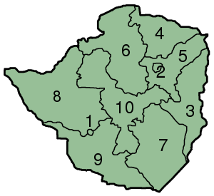
Provincias
| N.º | Provincia | Capital | Extensión | Población (2012) | Densidad |
|---|---|---|---|---|---|
| 3 | Manicalandia | Mutare | 36 459 | 1 762 698 | 48.35 |
| 4 | Mashonalandia Central | Bindura | 28 347 | 1 152 520 | 40.66 |
| 5 | Mashonalandia Oriental | Marondera | 32 320 | 1 344 955 | 41.61 |
| 6 | Mashonalandia Occidental | Chinhoyi | 57 441 | 1 501 656 | 26.14 |
| 7 | Masvingo | Masinvo | 56 566 | 1 485 090 | 26.25 |
| 8 | Matabelelandia Septentrional | Lupane | 75 025 | 749 017 | 9.98 |
| 9 | Matabelelandia Meridional | Gwanda | 54 172 | 683 893 | 12.62 |
| 10 | Midlands. | Gweru | 49 166 | 1 614 941 | 32.85 |
| 389.496 | 10.294.770 | 26,43 |
| Control de autoridades |
|
|---|
 Datos: Q3976660
 Multimedia: Subdivisions of Zimbabwe / Q3976660