To install click the Add extension button. That's it.

The source code for the WIKI 2 extension is being checked by specialists of the Mozilla Foundation, Google, and Apple. You could also do it yourself at any point in time.

4,5
Kelly Slayton
Congratulations on this excellent venture… what a great idea!
Alexander Grigorievskiy
I use WIKI 2 every day and almost forgot how the original Wikipedia looks like.
What we do. Every page goes through several hundred of perfecting techniques; in live mode. Quite the same Wikipedia. Just better.
.
Leo
Newton
Brights
Milds

Península de Tarjankut

De Wikipedia, la enciclopedia libre

Mapa de Crimea con la península ubicada al noroeste de la misma.
Acantilado ubicado en la península.

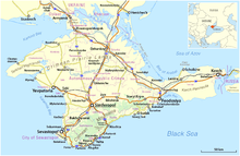
La península de Tarjankut (en ruso: полуостров Тарханкутский; en tártaro de Crimea: Tarhanqut Yarımadası; en ucraniano: Тарханкутський півострів) es la península que constituye el extremo occidental de Crimea en el mar Negro. En su costa norte está en la bahía de Karkinit.[1]​ Su punto más occidental es el cabo Priboiny, y al sur se encuentra el cabo Tarjankut. El terreno de la península es el altiplano Tarjankut.

Referencias

  1. Artículo "Тарханкутский полуостров" en la Gran Enciclopedia Soviética
Esta página se editó por última vez el 19 mar 2022 a las 12:55.
Basis of this page is in Wikipedia. Text is available under the CC BY-SA 3.0 Unported License. Non-text media are available under their specified licenses. Wikipedia® is a registered trademark of the Wikimedia Foundation, Inc. WIKI 2 is an independent company and has no affiliation with Wikimedia Foundation.